Table of Contents
ToggleUnveiling the Giants: Lake Mead and Lake Powell
Lake Mead: An Oasis Built by the Hoover Dam
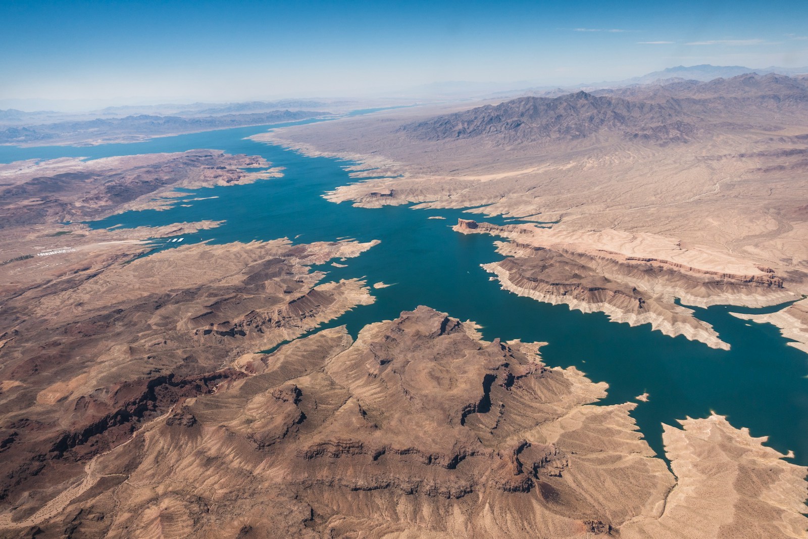
Lake Mead, the undisputed heavyweight champion when it comes to water storage in the United States, owes its existence to the monumental Hoover Dam. This impressive structure straddles the mighty Colorado River right on the border between Nevada and Arizona, a short drive, roughly 24 to 30 miles, to the east or southeast of the dazzling lights of Las Vegas. To truly grasp its immensity, just imagine: Lake Mead has the capacity to hold enough water to submerge the entire state of New York under a foot of water! This vast reservoir serves as more than just a scenic backdrop in the arid Southwest. It acts as a vital artery, supplying water to the states of Arizona, California, Nevada, and even parts of Mexico, sustaining the lives of nearly 20 million people and irrigating extensive agricultural lands. Lake Mead is the centerpiece of the Lake Mead National Recreation Area, a protected space that also encompasses the smaller Lake Mohave. This area offers a wide array of recreational activities throughout the year, drawing in visitors seeking respite and adventure. The primary source of water for Lake Mead is the snowmelt that originates high in the Rocky Mountains of Colorado, Wyoming, and Utah. However, a critical challenge facing this vital reservoir is that it consistently loses more water than it receives annually – approximately 1.2 million acre-feet – due to evaporation and the substantial amounts of water delivered downstream. This persistent deficit underscores a fundamental problem: the demands placed on Lake Mead are exceeding its natural replenishment rate. The sheer scale of the reservoir emphasizes its crucial role in water storage for the region, yet this ongoing imbalance raises serious concerns about the long-term sustainability of current water usage patterns, especially given the reliance on the unpredictable nature of snowmelt.
Lake Powell: A Reservoir Amidst Red Rock Wonders
Venturing northeast from Lake Mead, one encounters the breathtaking Lake Powell, another significant reservoir on the Colorado River, this time straddling the border between Utah and Arizona. Unlike the bustling surroundings of Lake Mead, Lake Powell is renowned as a major vacation destination, attracting around two million visitors each year who come to immerse themselves in its stunning red rock landscapes and partake in a variety of recreational pursuits, including boating, hiking, and exploring its numerous intricate canyons. Stretching for an impressive 186 miles, Lake Powell boasts a shoreline that extends for nearly 2,000 miles – a distance greater than the entire west coast of the United States! This aquatic marvel was created in 1963 when the Glen Canyon Dam was completed, holding back the waters of the Colorado River and forming this vast reservoir. The lake is named in honor of John Wesley Powell, a pioneering explorer who meticulously charted much of this rugged territory back in 1869. Lake Powell’s existence highlights a tension between its role as a recreational haven and its primary function as a crucial water storage facility. This becomes particularly evident during periods of drought, when both recreational access and the availability of water for downstream users are significantly impacted. The allure of Lake Powell as a tourist magnet underscores the economic importance of recreation in this region. However, its formation through the damming of Glen Canyon and its fundamental purpose as a water reserve mean that the needs of the environment and consumptive water users can often clash with the desires of those seeking leisure and adventure, especially when water levels experience significant declines.
How Did These Lakes Come to Be? The Formation Stories
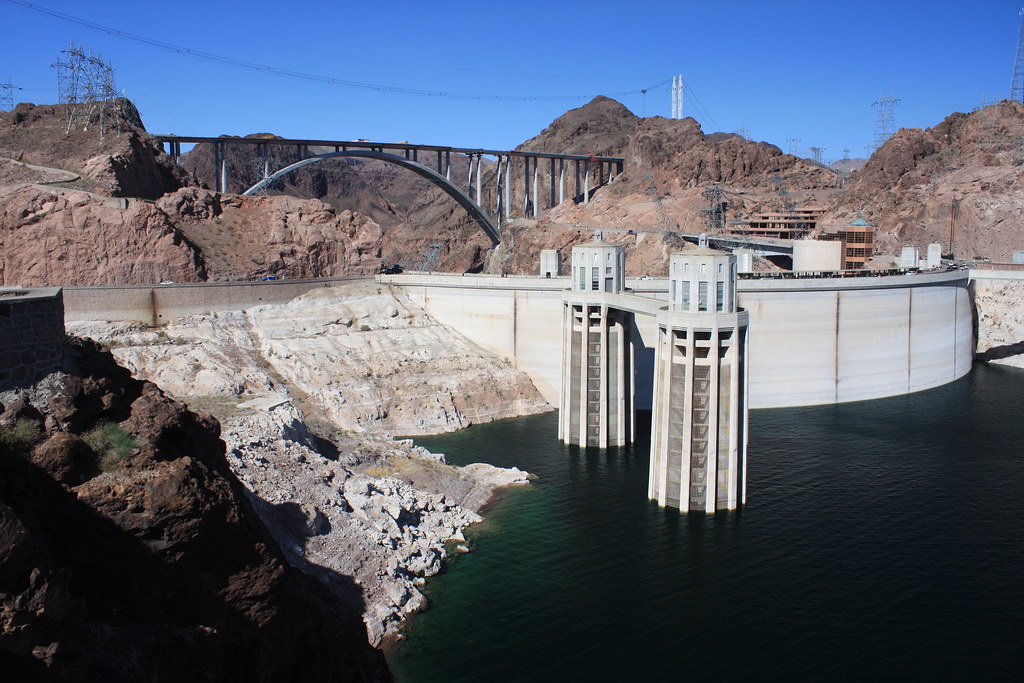
The story of Lake Mead began in 1935, a direct result of the completion of the Hoover Dam (originally known as Boulder Dam) in the dramatic Black Canyon. As the final construction phases concluded, the powerful waters of the Colorado River began their gradual ascent, filling the basin and giving birth to the reservoir. At the time of its construction, Hoover Dam stood as an unparalleled feat of engineering, holding the distinction of being the largest hydroelectric dam ever built. Interestingly, the area surrounding the nascent Lake Mead holds the historical significance of being the very first national recreation area established in the United States, a designation it received in 1936. Decades later, in 1963, another significant chapter in the Colorado River’s history unfolded with the creation of Lake Powell, a consequence of the construction of the Glen Canyon Dam. The filling of Lake Powell was not an immediate event; it took a considerable 17 years for the water to finally reach its intended high-water mark. Both of these massive lakes are situated within a region that boasts a rich and ancient geological narrative. The landscapes surrounding them bear witness to a time when shallow seas covered the area, to the slow but relentless sculpting power of wind that formed towering sand dunes, and to the dramatic forces of volcanic activity that once reshaped the very face of the earth. The creation of these lakes through human intervention in the natural flow of the Colorado River was initially driven by the goals of flood control, reliable water storage, and the generation of hydroelectric power. However, these ambitious projects now face unforeseen challenges stemming from long-term environmental shifts that were not fully anticipated at the time of their inception.
More Than Just Pretty Water: The Primary Purposes
Lake Mead was conceived with a multitude of crucial purposes beyond its aesthetic appeal. Its primary functions include providing essential flood control for the lower reaches of the Colorado River, serving as a vast storage facility for irrigation water vital to agriculture, supplying water for the growing municipal and industrial needs of the Southwest, and generating significant amounts of hydroelectric power. Remarkably, Lake Mead has also been a reliable source of safe drinking water for the residents of Southern Nevada since the 1930s. Upstream, Lake Powell plays a distinct yet equally important role. It primarily functions as a long-term carryover water storage reservoir, particularly for the Upper Basin states of Wyoming, Colorado, New Mexico, and Utah. This stored water allows these states to utilize their allocated share of the Colorado River while ensuring they can meet their mandated delivery obligations to the Lower Basin states. Mirroring its downstream counterpart, the Glen Canyon Dam, which impounds Lake Powell, also generates a substantial quantity of hydroelectric power, distributing it to homes and businesses across several states in the region. Beyond these utilitarian functions, both Lake Mead and Lake Powell have become major recreational hubs, offering a wide array of activities that attract millions of visitors each year. The diverse purposes served by these two critical reservoirs create a complex web of stakeholders, each with their own potentially conflicting interests. This intricate network makes the process of water management and decision-making particularly challenging, especially during periods of increasing water scarcity when difficult choices and trade-offs become inevitable.
The Lifeline of the Southwest: The Colorado River Basin
Which States Rely on the Colorado River? A Seven-State Story
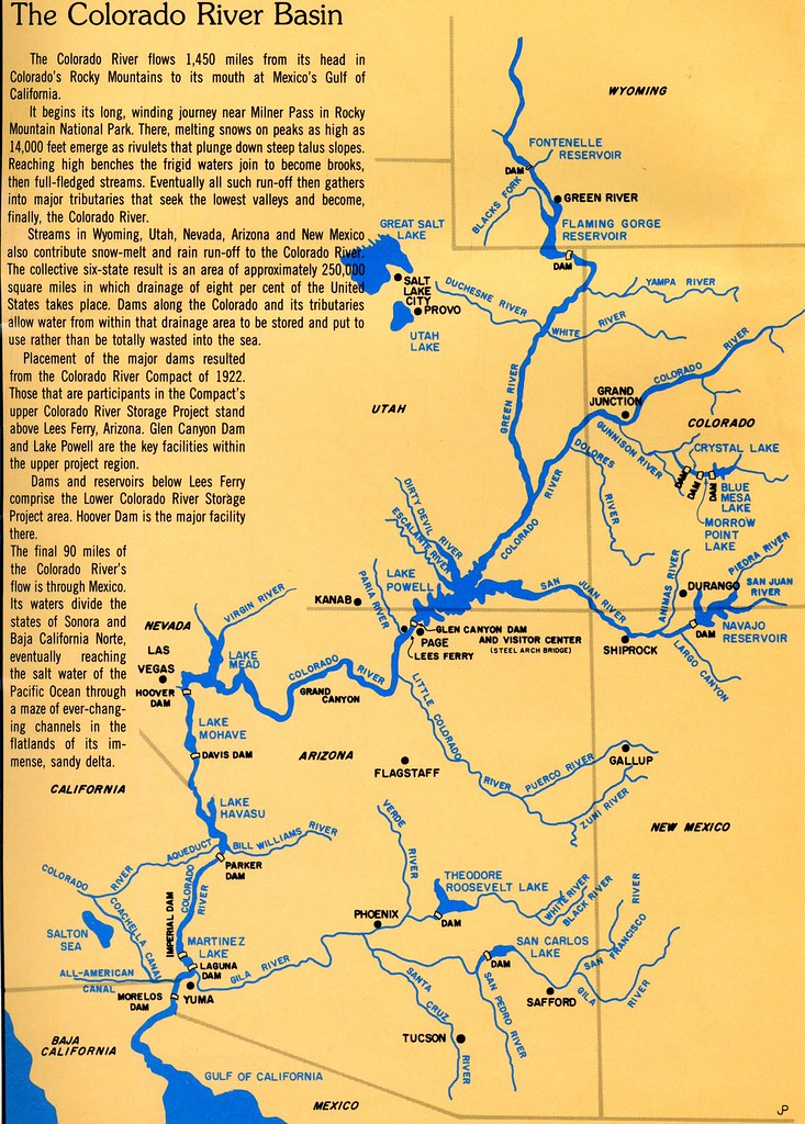
The Colorado River, a majestic waterway stretching for approximately 1,450 miles, serves as the fundamental water source for a total of seven states nestled in the Western United States: Arizona, California, Colorado, Nevada, New Mexico, Utah, and Wyoming. For administrative and management purposes, the vast area encompassed by the river and its tributaries, known as the Colorado River Basin, is typically divided into two distinct regions: the Upper Basin, which includes the states of Colorado, New Mexico, Utah, and Wyoming, and the Lower Basin, comprising Arizona, California, and Nevada. However, the significance of the Colorado River extends beyond the borders of the United States, as it also provides a crucial supply of water to the country of Mexico. To illustrate the river’s vital role, consider that the state of Colorado alone derives a substantial 40% of its entire water supply from the Colorado River system. Furthermore, this hardworking river irrigates millions of acres of farmland throughout the Southwest, playing a critical role in the production of food, including a significant portion of the nation’s winter vegetable crops. The fact that seven states and an entire nation depend on the water resources of a single river system underscores the immense potential for widespread impacts and the emergence of interstate conflicts when the availability of this precious resource becomes increasingly limited.
The Cornerstone: Understanding the Colorado River Compact
At the heart of the intricate web of water management in the Colorado River Basin lies the Colorado River Compact, a foundational agreement established in 1922. This landmark compact effectively divided the Colorado River Basin into two distinct areas: the Upper Basin and the Lower Basin, with the dividing line situated at Lee Ferry, Arizona. The core principle of the Compact was the apportionment of water for beneficial consumptive use, with each of the two basins being allocated 7.5 million acre-feet of water per year. Additionally, the Upper Basin states undertook an obligation to ensure that the flow of the river at Lee Ferry would not be depleted below an aggregate of 75 million acre-feet over any consecutive ten-year period. The negotiators who crafted this agreement in the early 1920s relied on the best available hydrological data at the time, which suggested an average annual flow of the Colorado River at Lee Ferry in the range of 17 to 18 million acre-feet. However, subsequent long-term measurements have revealed that this initial estimate was somewhat optimistic, highlighting a fundamental challenge in the original framework.
Navigating the Waters: Subsequent Water Allocation Agreements
The Colorado River Compact of 1922 served as the initial framework for water allocation, but it was by no means the final word. Over the ensuing decades, a complex and evolving body of interstate compacts, federal laws, court decisions and decrees, contracts, and federal actions, collectively known as the “Law of the River,” has further shaped the management and distribution of the Colorado River’s water. For instance, the Boulder Canyon Project Act, enacted in 1928, authorized the construction of the Hoover Dam and specifically allocated the Lower Basin’s share of water among the states of Arizona, California, and Nevada. In 1944, a significant treaty was established with Mexico, guaranteeing an annual delivery of 1.5 million acre-feet of Colorado River water to the neighboring nation. The Upper Basin states also formalized their internal water division in 1948 through the Upper Colorado River Basin Compact. More recent efforts to address the growing challenges of water scarcity include the implementation of the 2007 Interim Guidelines for Lower Basin Shortages and Coordinated Reservoir Operations, as well as the development of the 2019 Drought Contingency Plans (DCPs) for both the Upper and Lower Colorado River Basins. These ongoing adjustments and adaptations demonstrate a continuous effort to manage the river’s resources in the face of changing conditions. However, the persistent water crisis suggests that these measures, while important, may not be entirely sufficient to overcome the long-term impacts of drought and the overarching influence of climate change on the Colorado River system.
Troubling Times: The Current State of Water Levels
The Shrinking Shorelines: Recent Trends in Lake Levels
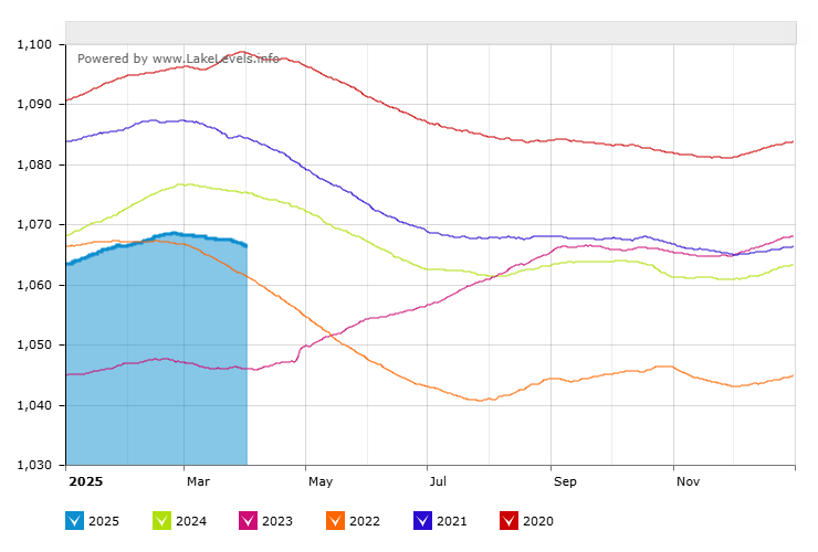
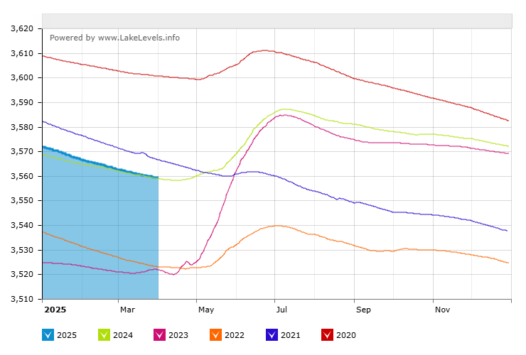
Examining the recent trends in water levels at both Lake Mead and Lake Powell reveals a concerning picture. As of February 2025, the water level in Lake Mead was approximately 1,067 feet above mean sea level (MSL). While this figure might seem substantial, it represents a significant shortfall compared to the reservoir’s full pool level of 1,229 feet. Although there have been some encouraging signs of slight increases in water levels in recent months, the overall trajectory when viewed against historical data from past decades clearly indicates a long-term decline. The situation at Lake Powell, located upstream, mirrors this troubling trend. As of April 2025, the water level in Lake Powell was recorded at around 3,559 feet. This level is also considerably below the reservoir’s full capacity of 3,700 feet. A particularly concerning aspect of Lake Powell’s current state is that it has been experiencing a net loss of water, with the amount of water flowing out of the reservoir exceeding the amount flowing in. These recent trends in water levels underscore a critical reality: the Colorado River system is facing a persistent and significant water deficit.
A Look Back: Historical Context of Water Levels
To truly appreciate the severity of the current situation, it is essential to consider the historical context of water levels in Lake Mead and Lake Powell. Lake Mead reached its highest recorded level in July 1983, when the water surface reached an elevation of 1,225 feet. In stark contrast, the reservoir experienced its lowest level in July 2022, plummeting to a mere 1,040 feet. Similarly, Lake Powell has not reached its full capacity since the summer of 1983. The reservoir hit a historic low in February 2023, with water levels dropping to 3,521.77 feet. Notably, the period spanning from 2000 to 2022 represents the lowest 23-year period of unregulated inflow into Lake Powell since the Glen Canyon Dam was completed in 1963. This historical data clearly illustrates a significant downward trend in the water levels of both Lake Mead and Lake Powell over the past two decades. This decline coincides with a prolonged period of drought in the region, indicating a marked shift from the wetter conditions that characterized the earlier years following the reservoirs’ creation.
What’s Causing the Crisis? Factors at Play
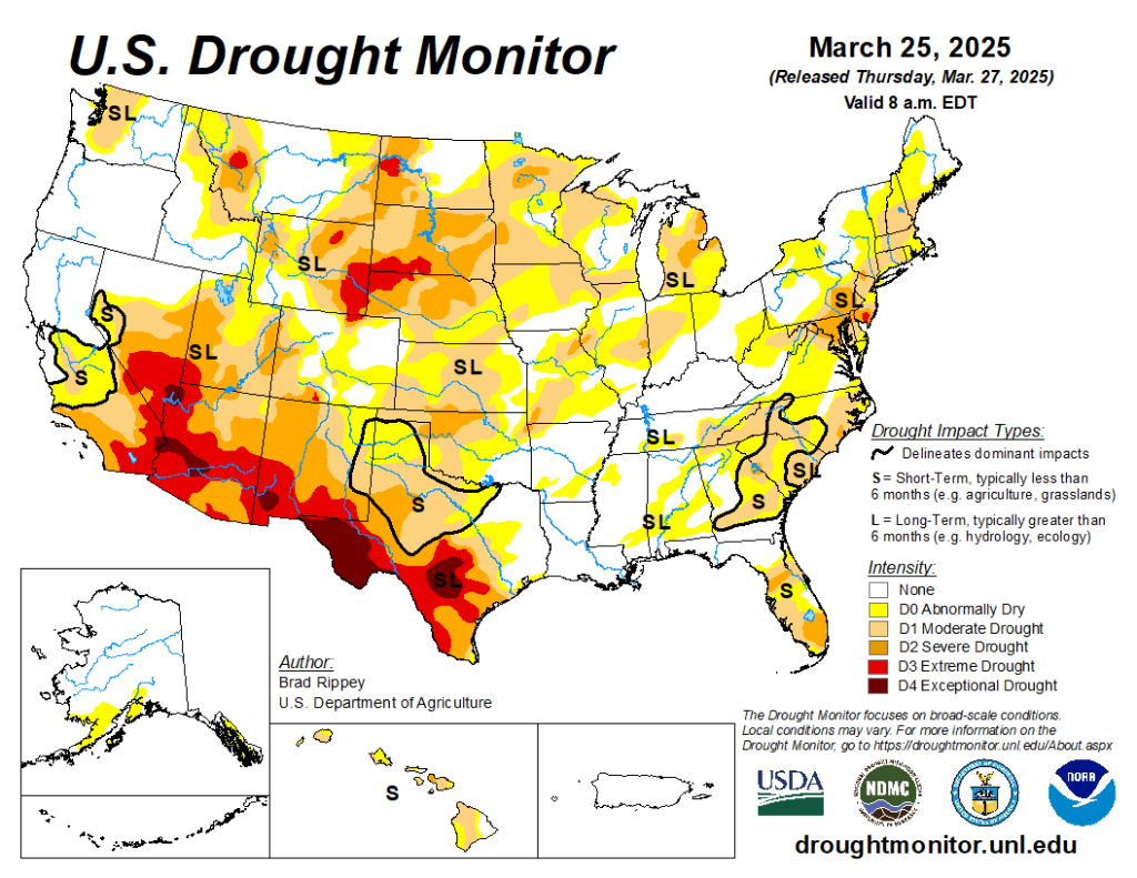
The ongoing crisis of declining water levels in Lake Mead and Lake Powell is not attributable to a single cause but rather a complex interplay of several interconnected factors. One of the most significant contributors is the prolonged drought that has gripped the American Southwest for over two decades, exacerbated by the impacts of climate change. This has resulted in reduced snowfall in the Rocky Mountains, the primary source of the Colorado River’s water, and increased rates of evaporation from the reservoirs. Furthermore, research suggests that warmer and drier spring conditions are leading to a decrease in rainfall, causing vegetation to consume a greater portion of the melting snowpack before it can reach rivers and streams. Another fundamental issue is the overallocation of the Colorado River’s water resources. The original Colorado River Compact and subsequent agreements were based on historical flow estimates that now appear to have been overly optimistic, leading to a situation where more water has been allocated than the river can reliably supply. The increasing demand for water due to the rapid population growth in the Southwestern states also places significant strain on the already limited resources. Finally, the agricultural sector, which is the largest single consumer of water in the Colorado River Basin, plays a crucial role in the overall water balance.
Nature Under Threat: Environmental Consequences
Ripples Through the Ecosystem: Impacts on Aquatic Life
The declining water levels in Lake Mead and Lake Powell are not merely a visual concern; they are triggering significant environmental consequences, particularly for the delicate aquatic ecosystems within and downstream of the reservoirs. As water volumes decrease, water temperatures tend to rise, which can lead to an increase in the growth of algae, including potentially harmful cyanobacteria, also known as blue-green algae. These algal blooms can negatively impact water quality and pose risks to both aquatic life and human health. Furthermore, the altered water temperatures and flow regimes can severely affect native fish species, many of which have evolved specifically to thrive in the unique conditions of the Colorado River system and are now facing the threat of endangerment or extinction. For instance, the low water levels in Lake Powell have created an opportunity for non-native predatory fish, such as the smallmouth bass, to migrate downstream through the Glen Canyon Dam and pose a direct and immediate threat to the already vulnerable humpback chub population within the Grand Canyon.
Drying Lands: Effects on Riparian Habitats
The diminished flow of the Colorado River, coupled with the lower water levels in Lake Mead and Lake Powell, is also having a profound impact on the riparian habitats that line the riverbanks and surround the reservoirs. These riparian zones, characterized by lush vegetation adapted to the presence of water, provide critical habitat for a wide variety of birds, mammals, and other wildlife. As water becomes scarce, riparian forests and wetlands are shrinking, leading to a loss of biodiversity and a decline in the overall ecological health of these areas. A stark example of this is the once-vibrant Colorado River Delta in Mexico, where decades of reduced river flow have led to the desiccation of vast wetland ecosystems and the disappearance of much of the wildlife that once flourished there. Additionally, changes in fire regimes, which are being intensified by the hotter and drier conditions associated with climate change, can further degrade riparian habitats, making them more susceptible to erosion and the loss of native plant species.
A Fight for Survival: Challenges for Endangered Species
The Colorado River Basin is a biodiversity hotspot, home to a remarkable array of native fish species, including four that are currently listed as endangered or threatened and are found nowhere else on Earth: the Colorado pikeminnow, the razorback sucker, the bonytail chub, and the humpback chub. The construction of dams and reservoirs, along with the diversion of water for human uses, has significantly altered the natural flow and temperature regimes of the river, impacting the habitats these unique fish rely on. Furthermore, the introduction of numerous non-native fish species, many of which are predatory, has created additional pressures on the native fish populations. The current crisis of low water levels and warmer water temperatures further exacerbates these challenges, potentially stressing the already vulnerable native species beyond their tolerance limits and creating more favorable conditions for non-native competitors and predators. The precarious situation of these endangered species serves as a critical indicator of the severe environmental strain that the Colorado River system is currently experiencing, underscoring the urgent need for effective conservation and management strategies.
When Water Runs Low: Economic Impacts
Parched Fields: Agriculture Under Pressure
As the largest consumer of water in the Colorado River Basin, the agricultural sector is facing significant challenges due to the ongoing water shortages. Reduced water allocations are forcing farmers to make difficult decisions, such as leaving fields fallow, switching to crops that require less water, or increasing their reliance on groundwater pumping, which can have its own set of environmental and economic consequences. These cuts in irrigation water can lead to substantial economic losses in terms of reduced crop yields and sales, impacting not only the farmers themselves and the farmworkers they employ but also the broader economies of rural communities that depend on agriculture for their vitality. The Colorado River Basin supports a multi-billion dollar agricultural industry that plays a crucial role in the nation’s food supply, particularly in the production of fruits, vegetables, and livestock. The economic repercussions of water shortages in this sector can therefore extend far beyond the local level, potentially affecting food prices and the availability of certain agricultural products across the country.
Dimming the Lights: Hydropower Generation at Risk
The iconic Hoover and Glen Canyon Dams, which impound Lake Mead and Lake Powell respectively, are not only critical for water storage but also serve as major sources of hydroelectric power for the Southwest. The Glen Canyon Powerplant alone generates approximately five billion kilowatt-hours of electricity annually, contributing significantly to the energy needs of Wyoming, Utah, Colorado, New Mexico, Arizona, Nevada, and Nebraska. However, the declining water levels in both reservoirs pose a significant threat to the continued operation of these hydroelectric facilities. If water levels drop below a critical threshold known as the minimum power pool, the dams may no longer be able to generate electricity, leading to potential energy shortages and an increased reliance on alternative, often fossil fuel-based, energy sources. Even before reaching this critical point, the historically low water levels have already resulted in a reduction in hydropower generation efficiency, further highlighting the economic and energy security implications of the ongoing water crisis.
Empty Beaches and Dry Docks: Recreation and Tourism Hit Hard
The scenic beauty and recreational opportunities offered by Lake Mead and Lake Powell have long been significant drivers of tourism in the Southwest, attracting millions of visitors from across the country and beyond. However, the persistent decline in water levels is having a direct and negative impact on these vital industries. As the lakes recede, boat ramps become unusable, marinas are forced to close or reduce services, and the overall visitor experience is diminished. The Lake Mead National Recreation Area and the Glen Canyon National Recreation Area, which encompass these reservoirs, are major economic engines for the surrounding communities. The reduction in tourism due to the water crisis is leading to significant financial losses for local businesses, including hotels, restaurants, tour operators, and other establishments that rely on visitor spending. This downturn in the recreation and tourism sectors further exacerbates the economic challenges facing the region as a result of the Colorado River water shortage.
Thirsty Cities: Municipal Water Supplies in Jeopardy
A significant portion of the population in the Southwestern United States relies on the Colorado River system for their municipal water supplies, including major metropolitan areas such as Las Vegas, Los Angeles, Phoenix, and Denver. The declining water levels in Lake Mead, the largest reservoir in the system, can trigger mandatory water cutbacks for states like Nevada and Arizona, impacting residential and commercial water users. Furthermore, if Lake Mead’s water level were to fall below a critical elevation known as “dead pool” (895 feet), the flow of water through Hoover Dam to downstream users in California, Arizona, and Mexico could cease entirely. To mitigate the risks associated with these potential water shortages, urban communities are increasingly being forced to invest in water conservation measures, such as promoting water-efficient landscaping and appliances, and exploring alternative water supply options, which can often result in increased costs for consumers. The ongoing water crisis thus poses a direct and growing threat to the water security of millions of people living in the Southwest, necessitating significant adaptations in water management practices and individual consumption habits.
Turning the Tide: Current Water Management and Conservation
Smarter Farming: Agricultural Water Conservation Techniques
Recognizing that agriculture is the dominant water user in the Colorado River Basin, significant efforts are underway to promote and implement more efficient water management practices within this sector. Farmers are increasingly adopting advanced irrigation technologies such as drip irrigation, which delivers water directly to the roots of plants, minimizing evaporation and runoff; low-pressure sprinkler systems, which also reduce evaporative losses compared to traditional high-pressure systems; and laser land leveling, which ensures a more uniform distribution of water across fields. Additionally, there is a growing interest in transitioning to crop varieties that require less water and in implementing regenerative agricultural practices that enhance soil health and its capacity to retain moisture. To facilitate these changes, various financial incentives and technical assistance programs are being offered to agricultural producers to encourage the adoption of water-saving technologies and practices. While these advancements hold considerable promise for improving water use efficiency in agriculture, their widespread adoption faces challenges related to the upfront costs of new equipment and the complexities of navigating existing water rights structures and regulations.
Urban Savers: Water Restrictions and Efficiency in Cities
Urban centers throughout the Colorado River Basin are also actively engaged in implementing a range of water management strategies and conservation measures to reduce their reliance on the river’s dwindling supplies. Many municipalities have instituted mandatory seasonal water restrictions, limiting outdoor watering during the hottest and driest parts of the year. Additionally, numerous cities offer rebate programs to encourage residents and businesses to replace water-intensive lawns with drought-tolerant landscaping and to upgrade to water-efficient appliances and fixtures. The Southern Nevada Water Authority, serving the Las Vegas metropolitan area, has achieved remarkable success in reducing per capita water use through a comprehensive suite of conservation programs. Furthermore, an increasingly important strategy for urban water management is the expansion of water recycling and reuse programs, where treated wastewater is purified and used for non-potable purposes such as irrigation and industrial processes, thereby stretching existing water supplies.
Working Together: Interstate Agreements for Water Reduction
Addressing the Colorado River water crisis requires a collaborative approach that transcends state boundaries. To this end, the seven basin states have been actively involved in negotiating and implementing interstate agreements aimed at reducing overall water consumption from the river system. A prime example of such cooperation is the Drought Contingency Plan (DCP), which outlines specific water use reductions for the Lower Basin states based on the water levels in Lake Mead. In a significant development, the Lower Basin states have agreed to voluntarily conserve a substantial amount of water through the year 2026, with financial compensation provided by the federal government to support these efforts. Looking beyond the near term, the basin states are currently engaged in intensive negotiations to establish the rules and guidelines that will govern the management of the Colorado River beyond the expiration of the current interim guidelines in 2026. These ongoing discussions highlight the critical need for continued collaboration and compromise among the basin states to forge a sustainable path forward for the Colorado River in the face of persistent water scarcity.
A Vision for the Future: Sustainable Solutions
Watering Wisely: Advancements in Irrigation Technology
Securing a sustainable future for the Colorado River Basin necessitates a continued focus on advancing and implementing water-efficient irrigation technologies in agriculture. Ongoing research and development are yielding increasingly sophisticated methods for delivering water to crops with greater precision and minimal waste. This includes the refinement of existing techniques like drip irrigation and low-pressure sprinklers, as well as the exploration of innovative approaches such as mobile drip irrigation and the use of soil moisture sensors to optimize water application. Furthermore, the integration of satellite-based farm management solutions offers the potential for real-time monitoring of crop health and water needs, enabling farmers to apply water only where and when it is most required. While these technological advancements hold significant promise for enhancing water use efficiency in agriculture, their widespread adoption will require addressing the financial barriers that many farmers face and ensuring that these technologies ultimately lead to a net reduction in water consumption across the entire Colorado River Basin.
Second Chance Water: The Potential of Recycling and Reuse
In the face of dwindling water supplies, expanding the use of water recycling and reuse programs represents a crucial strategy for augmenting water availability in the Colorado River Basin. By treating and reusing wastewater from municipal and industrial sources, communities can significantly reduce their reliance on the Colorado River. Several regions within the basin are already making significant strides in this area. For example, Southern California is investing heavily in large-scale wastewater recycling projects aimed at producing a substantial new source of clean water. Similarly, the city of Las Vegas has emerged as a leader in water reuse, effectively recycling nearly all of its indoor water to extend its available supply. While water recycling and reuse offer a compelling pathway towards greater water sustainability, the implementation of such programs often requires substantial capital investment in infrastructure and overcoming potential public concerns regarding the safety and quality of recycled water.
Tapping the Ocean: The Role of Desalination
For the Lower Basin states, particularly those with access to the Pacific Ocean, seawater desalination presents a potential, albeit complex and often debated, solution for supplementing their water supplies. This technology involves removing salt and other minerals from seawater to produce freshwater suitable for various uses. California has already made significant investments in desalination technology, with facilities like the Carlsbad Desalination Plant now providing a portion of the region’s water demand. There have even been discussions about the feasibility of developing a binational desalination plant in the Sea of Cortez, a project that could potentially provide a new water source for both the United States and Mexico. While desalination offers the significant advantage of providing a drought-proof water source, it is also an energy-intensive and expensive process, and the disposal of the resulting brine can pose environmental challenges. Therefore, the role of desalination in the future water management of the Colorado River Basin requires careful consideration of its economic, environmental, and social implications.
Charting a New Course: Policy Recommendations for Sustainability
Achieving long-term sustainability for the Colorado River system will necessitate significant policy changes that address the fundamental imbalances between water supply and demand. This includes exploring the implementation of more flexible water sharing mechanisms that can adapt to the natural variability of the river’s flow, rather than relying on fixed annual allocations. Policymakers may also need to consider establishing and enforcing stricter water usage caps for both the Upper and Lower Basin states, coupled with robust monitoring systems to ensure compliance. Furthermore, fostering greater collaboration and engagement among all stakeholders, including farmers, municipalities, tribal nations, and the public, in water management decisions is crucial for developing equitable and effective solutions. It is also essential to better integrate the latest scientific understanding of climate change and its impacts on hydrology into water management planning and operational strategies. Ultimately, a comprehensive approach to securing the future of the Colorado River may require revisiting and potentially reforming the foundational Colorado River Compact to reflect current realities, account for the needs of all stakeholders, and establish a more adaptive and resilient framework for water allocation and management.
The Ongoing Conversation: Debates and the Future of the Colorado River
Whose Water Is It? Perspectives on Water Rights
The allocation and management of water from the Colorado River remain subjects of intense discussion and debate, particularly concerning the complex issue of water rights. A significant aspect of this ongoing conversation involves the water rights of Native American tribes within the basin, many of which are still in the process of being fully recognized and settled. The legal principle of prior appropriation, often summarized as “first in time, first in right,” further complicates the allocation of water, especially during periods of shortage when those with senior water rights typically have priority over junior users. The diverse perspectives and often competing claims to the Colorado River’s water highlight the intricate legal and historical context that must be navigated in the pursuit of sustainable water management solutions.
Potential Flashpoints: The Risk of Interstate Conflicts
As the water resources of the Colorado River become increasingly strained, the potential for disagreements and even conflicts among the seven basin states is heightened. Differing water needs, priorities, and historical entitlements among the states can lead to significant challenges in reaching consensus on proposed solutions for water allocation and conservation. The impending expiration of the current interim management guidelines in 2026 adds a sense of urgency to the need for a new agreement, but it also creates a potential for conflict if the states are unable to find common ground and develop a unified approach to managing the river in the years to come. The high stakes involved in securing access to this vital resource underscore the importance of strong leadership and a willingness to compromise among all the basin states to ensure a sustainable and equitable future for the Colorado River system.
Thinking Outside the Box: Innovative Approaches for Long-Term Sustainability
Addressing the long-term sustainability of the Colorado River in the face of persistent drought and climate change will likely require exploring innovative approaches that go beyond traditional water management strategies. This includes considering alternative water sources that are not directly reliant on the Colorado River system, although such options often face significant logistical, economic, and environmental hurdles. The development and implementation of cutting-edge water management technologies, such as artificial intelligence-driven systems for more accurate water demand forecasting and smart water metering infrastructure to improve conservation efforts, are also being explored. Furthermore, there is a growing recognition of the need to re-evaluate the operational paradigms of major reservoirs like Lake Mead and Lake Powell, giving greater consideration to environmental flows and the overall ecological health of the river system, in addition to their traditional roles in water storage and hydropower generation.
Conclusion: Securing the Future of a Vital Resource
The Colorado River crisis, exemplified by the declining water levels in Lakes Mead and Powell, presents a formidable challenge demanding immediate and sustained attention. The intricate web of historical agreements, increasing demands, and the undeniable impacts of climate change necessitate a paradigm shift in how we manage this vital resource. While current conservation efforts and interstate collaborations offer glimmers of hope, the long-term sustainability of the Colorado River hinges on embracing innovative solutions, fostering equitable water allocation policies, and cultivating a collective commitment to safeguarding this lifeline of the Southwest for generations to come.
Frequently Asked Questions (FAQs)
FAQ 1: What are the main reasons for the Colorado River water crisis?
The primary drivers of the Colorado River water crisis are a prolonged drought exacerbated by climate change, which has reduced snowpack and increased evaporation; the overallocation of the river’s water based on historical flow estimates that were likely too high; and the increasing demand for water due to population growth and agricultural needs in the Southwest.
FAQ 2: How are the declining water levels in Lake Mead and Lake Powell impacting people and the environment?
The declining water levels are having widespread impacts, including threatening municipal water supplies for major cities, reducing the capacity for hydroelectric power generation at Hoover and Glen Canyon Dams, harming aquatic ecosystems and riparian habitats, endangering native fish species, and negatively affecting recreation and tourism industries that rely on the lakes.
FAQ 3: What are some of the ways we can conserve water in the Colorado River Basin?
Water conservation efforts include adopting water-efficient irrigation technologies in agriculture, implementing urban water restrictions and promoting water-wise landscaping, expanding water recycling and reuse programs in cities and industries, and fostering interstate agreements among the basin states to reduce overall water consumption.
FAQ 4: Are there any long-term solutions being considered for the Colorado River water shortage?
Potential long-term solutions include further advancements in water-efficient irrigation, expanding water recycling and reuse infrastructure, exploring the feasibility of desalination, and implementing policy changes that promote more flexible and equitable water allocation based on current climate realities.
FAQ 5: What is the Colorado River Compact, and why is it important?
The Colorado River Compact of 1922 is a foundational agreement that divided the Colorado River Basin into the Upper and Lower Basins and allocated 7.5 million acre-feet of water per year to each. It is important because it established the initial framework for water sharing among the seven basin states and continues to influence water management decisions in the region, although its original assumptions are now being challenged by current conditions.

