For researchers, policymakers, and agricultural planners following the latest Lake Mead water level news, the hydrological data for 2026 reveals a system under unprecedented stress. As the Colorado River Basin grapples with another year of severe snow drought, tracking real-time reservoir elevations is critical for understanding regional water security and impending shortage declarations.
This live dashboard integrates daily telemetry from the US Bureau of Reclamation (USBR) and the USGS to provide an expert-level overview of the Western Water Crisis.
Table of Contents
Colorado River Basin
Climate Intelligence
Lake Mead Elevation
— ft ASLUSGS 09421000
Lake Powell Elevation
— ft ASLUSGS 09379900
Great Salt Lake
— ft ASLSyncing…
Snowpack
— Inches (SWE)Syncing…
Analyzing the Latest Lake Mead Water Level News
When viewing the live telemetry above, it is vital to practice systems thinking. Looking at Lake Mead in isolation provides an incomplete, and often misleading, hydrological picture.
As of April 2026, Lake Mead may show marginal elevation gains or stabilization. However, this is largely a “paper gain” engineered by strategic water releases from upstream. The true indicator of systemic health lies further north in the Rocky Mountains and the upper basin reservoirs.
The 2026 “Snow Drought” and Minimum Power Pool Risks
The leading indicator for the Colorado River Basin is the Snow Water Equivalent (SWE). Currently, the upper basin snowpack is hovering at a critical 6.4 inches, representing roughly 24% of the 30-year historical median.
Because the winter storms failed to deliver sufficient snowpack, the “Upper House” of the river system, Lake Powell, is in a state of terminal decline. As Lake Powell’s elevation drops closer to 3,525 feet, it flirts dangerously with the Minimum Power Pool. If the water drops below the penstocks at Glen Canyon Dam, the facility can no longer generate hydroelectric power, threatening grid stability across several Western states.
Reference Data: 2026 Reservoir Status Baseline
The following table contextualizes the live dashboard metrics against their absolute capacities and critical thresholds.
| Reservoir System | Critical Threshold (Elevation) | Current 2026 Status Context | Systemic Impact |
| Lake Mead | 1,050 ft (Tier 2 Shortage) | ~1,064 ft (Propped by upstream releases) | Agricultural water allocations severely restricted in AZ and NV. |
| Lake Powell | 3,490 ft (Minimum Power Pool) | ~3,526 ft (Declining due to snow drought) | Hydroelectric generation failure; loss of grid baseload. |
| Great Salt Lake | 4,198 ft (Ecological baseline) | ~4,192 ft (Exposed lakebed) | Toxic dust exposure; collapse of local brine shrimp industry. |
How the Super El Niño is Diverting Precipitation
The current hydrological deficit is not an anomaly; it is a direct result of shifting global climate mechanics. The anticipated atmospheric moisture from the Pacific has bypassed the crucial watersheds of the Colorado River Basin.
This divergence is heavily tied to the mechanics we outlined in our recent analysis of the 2026 Super El Niño: Climate Mechanics and Global Weather Outlook. Instead of depositing dense snowpack in the Rockies, the subtropical jet stream has funneled precipitation into localized atmospheric rivers, leaving the primary water-storage regions entirely parched.
Preparing for a Tier 2 Shortage Declaration
Without a miraculous 150% snowpack recovery by early 2027, the USBR will be forced to implement a Tier 2 Shortage Declaration for Lake Mead.
This declaration will trigger mandatory, deep cuts to water allocations. The agricultural sector, which consumes roughly 80% of the basin’s water, will bear the brunt of these reductions. Farmers will be forced to aggressively transition to precision agriculture, fallow thousands of acres of water-intensive crops like alfalfa, or rely on groundwater pumping.
To calculate the specific water impact of various agricultural and lifestyle choices, researchers and consumers can utilize our Water Footprint Calculator.
Data Sources & Further Reading:
- US Bureau of Reclamation (USBR): Lower Colorado River Operations and Lower Basin Shortage Guidelines.
- National Resources Conservation Service (NRCS): Snow Telemetry (SNOTEL) and Snow Course Data Network.
Frequently Asked Questions: Lake Mead Elevation & Drought
How deep is Lake Mead today?
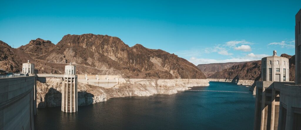
The exact depth of Lake Mead fluctuates daily based on Bureau of Reclamation releases and upstream snowmelt. As of our latest lake mead elevation today telemetry, the surface water sits at approximately 1,064 feet above sea level. At maximum capacity (1,221 feet), the lake reaches a maximum depth of around 532 feet.
What is the Lake Mead dead pool level?
The lake mead dead pool level is 895 feet above sea level. At this elevation, water can no longer flow past the Hoover Dam, meaning downstream allocations to California, Arizona, and Mexico would be physically cut off, and hydroelectric power generation would cease entirely.
Why is Lake Mead drying up?
The lake mead drought is the result of a two-decade systemic imbalance in the Colorado River Basin. A persistent “snow drought” in the Rocky Mountains—exacerbated by shifting global climate patterns like the El Niño Southern Oscillation—has drastically reduced the annual inflow into Lake Powell, which directly feeds Lake Mead.